The aerial imagery problem nobody talked about, and how it got solved
May 2026
Chris Formeller, CPCombining high resolution with frequent updates is where the real advantage of aerial imagery lives. You are not just seeing the area, you track what’s changed, prioritize work, reduce site visits, and document conditions with the confidence that what you are looking at is accurate.
May 2026
Chris Formeller, CP)
LONG ISLAND CITY NY US
For years, buying aerial imagery meant picking your poison.
You could get incredible detail, but the imagery was old by the time it reached you. Or you could get wide coverage, but resolution was too low to confidently make decisions from.
That tradeoff was tolerable when aerial imagery was a background layer. It stops being that when teams are making decisions that depend on data being both sharp and current: pricing risk, planning infrastructure, scoping a construction site, assessing damage after an event. At scale, imagery that’s detailed but stale, or fresh but blurry, are both the wrong answer.
The Nearmap Standard Capture program delivers as low as 1.57” ground sampling distance (GSD) across metro-wide coverage, with up to three captures per year in the United States and six per year in Australia. For projects that need even greater precision, custom captures can reach 1” GSD or better. The goal was never a better spec sheet. It was imagery that holds up in the real world, across every decision and every property in a portfolio.
)
Resolution you can trust in the real world
GSD is where most conversations about aerial imagery start, for good reason. Two providers can claim the same GSD and deliver very different results when your team tries to measure something, verify a condition, or compare captures over time.
What makes the difference is whether the imagery is genuinely inspection-grade in practice. There are four things that determine this:
Radiometric quality is how well the imagery handles light and color. Good radiometric quality means details are not washed out in bright areas or lost in shadow. Poor radiometric quality means features that should be visible are not. This matters when you are trying to identify roof material, surface condition, or structural feature from the desktop.
Geometric accuracy is how well the imagery aligns to real-world coordinates. If the geometry is off, measurements are unreliable. That’s a problem for engineering, planning, and compliance workflows where precision is not optional. Nearmap imagery is evaluated against ASPRS accuracy standards, meaning measurements made from it are defensible in professional contexts.
Image sharpness is whether edges and fine details are crisp or softened by motion blur, optics, or processing. Sharpness is what determines whether you can confidently identify a specific feature (e.g., a cracked shingle, a pooling water mark, or a vegetation encroachment) from the desktop rather than sending someone to the site.
Processing consistency is whether quality is maintained across the entire coverage area, not just in a few best-looking sample tiles. Inconsistent processing is the most common failure mode of assembled imagery programs. The quality looks fine on a demo but varies across the entire portfolio.
In plain terms: imagery that is blurry, uneven, or slightly distorted can look fine at a glance, but breaks down the moment your team tries to measure something, verify a condition, or defend a decision built on it. When Nearmap says 1.57” GSD, it means a level of detail you can trust in real-world applications.
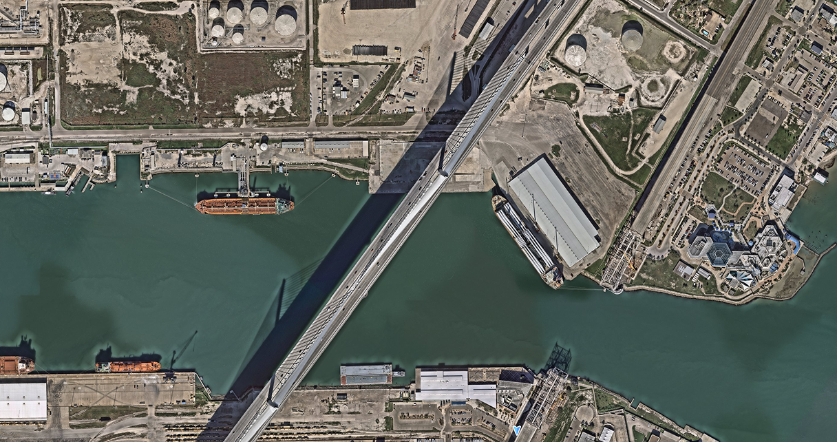
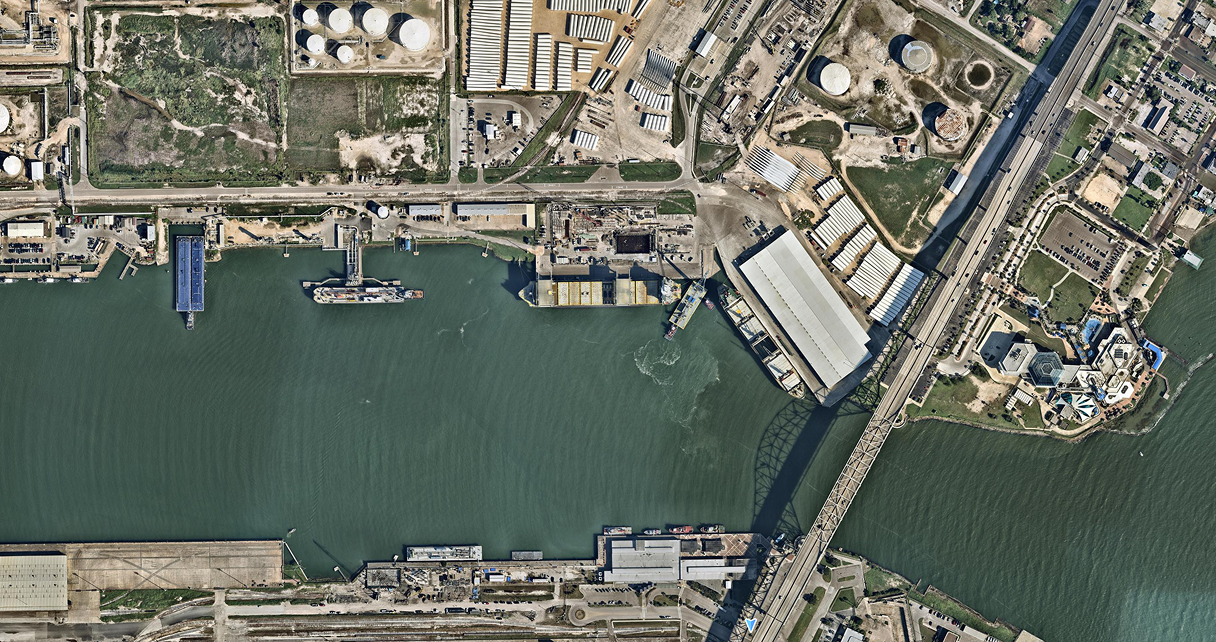
Port of Corpus Christi
Corpus Christi, TX
Currency matters, because the world changes fast
Resolution gets most of the attention during procurement. Freshness (how recent the imagery is) is often treated as secondary. It shouldn’t be.
The most detailed imagery in the world loses its value the moment the conditions it captured no longer exist. And conditions change faster than teams realize.
The built environment is always evovling. A building that appeared in last year’s capture may have been expanded or demolished. A roof that looked sound 18 months ago may have deteriorated significantly. A site that appeared clear might now have structures that affect every assessment built on the original data. After a major weather event, conditions change so rapidly that imagery captured before or weeks after tells a completely different story than imagery captured days after clearing.
Every one of those changes affects insurance pricing, claims assessment, compliance determinations, and risk management in ways that only current imagery reliably captures.
This is why combining high resolution with frequent updates is where the real advantage of aerial imagery lives. You are not just seeing the area. You can track what changed, prioritize work, reduce site visits, and document conditions with the confidence that what you are looking at is accurate.
)
What each imagery type actually does
Modern aerial intelligence is not one product. It’s a range of views, each designed for a specific job. Understanding what each type is built for helps teams get more from the imagery.
Vertical imagery is the foundation. The classic bird’s-eye view, captured at 1.57” to 2.95” GSD with multiple annual updates, is what most workflows depend on for base mapping, broad-area analysis, and tracking change over time. At this resolution and frequency, vertical imagery is the starting point for most property decisions, like spotting changes across a neighborhood or establishing a baseline for AI detection.
True ortho is vertical imagery corrected to reduce the distortions that make standard vertical imagery unreliable for precise measurement. This is particularly valuable for tall buildings and uneven terrain. True ortho produces imagery where scale is more consistent across every pixel. For engineering, planning, or compliance workflows where measurement accuracy needs to hold up, true ortho is the right starting point.
Oblique and panorama views fill the gap that vertical imagery can’t. Vertical imagery shows you the top of a building, oblique and panorama views show you the sides (roof features and conditions, building facades and exterior condition, windows, walls, and doors). For insurance claims review, property assessment, roofing workflows, and site evaluation, the ability to see a building from multiple angles eliminates the need for site visits that would otherwise be required.
3D products, including DSM, DTM, and Textured Mesh, add shape and depth to the imagery. The Digital Surface Model captures the tops of buildings and objects; the Digital Terrain Model represents the bare earth beneath them and the Textured Mesh creates a realistic, shareable 3D model. Together, they help teams understand how a place actually sits in the world: useful for infrastructure planning, construction, telecom design, and volumetric analysis.
Near-infrared (NIR) captures light outside the visible spectrum, revealing vegetation health and environmental signals that standard imagery can’t show. NIR is practical for environmental monitoring, vegetation management, and compliance workflows where the condition of vegetation relative to a structure is relevant to the decision being made.
Post-disaster intelligence is built for situations where every hour of delay has a direct cost. When disaster strikes, carriers, emergency managers, and government teams need a current, shared picture of what happened. Nearmap ImpactResponse mobilises to capture affected areas and deliver high-resolution imagery as early as 24 to 72 hours after clearing. This gives carriers, emergency managers, and government teams a shared picture of what happened before resources are misallocated.
)
Roundabout
Philadelphia, PA
Why comprehensive coverage changes the equation
The advantage of modern aerial intelligence is resolution, freshness, and coverage; maintained across a sustained program, not stitched together through bespoke captures. The distinction doesn’t show up on a spec sheet. It shows up when teams try to operate at scale.
A national insurer assessing risk across thousands of properties needs consistent quality whether they’re looking at properties in Sacramento or Philadelphia. If image quality varies by region, risk scoring becomes inconsistent across the book, which is a problem that amplifies at renewal. A government agency managing infrastructure across a growing jurisdiction needs coverage that updates predictably; project-by-project captures can leave some areas current and others more than a year behind.
This is what coverage planning produces that project-based captures cannot: repeatability. The ability to compare sites the same way every time. To track changes consistently across an entire portfolio. To document conditions with confidence, not with a footnote explaining which areas were captured under which program at which standard.
Nearmap coverage spans the vast majority of the US population, with comparable programs in Australia, Canada, and New Zealand, maintained at consistent resolution and quality across regular update cycles. That consistency is what makes standardised workflows possible, and standardised workflows are what make decisions defensible.
)
Tornado
Enid, Oklahoma
Current imagery acts. Historical imagery proves.
One dimension that rarely gets the attention it deserves is a deep, consistent historical archive. Current imagery gives teams immediate situational awareness, but historical imagery enables teams to prove what changed, and when. That capability matters in ways that only become clear when a decision is challenged:
An insurance adjuster determining whether roof damage is storm-related or pre-existing needs a dated historical capture that shows the property’s condition before the event.
A government compliance officer documenting an unapproved development needs captures that show not just that a structure exists, but when it appeared.
An engineering firm defending a design decision needs historical captures that are precise enough to show pre-existing site conditions at the time the design was developed.
The Nearmap historical archive extends back over a decade, all captured through the same owned pipeline and processed to consistent standards. The intellgience is date-stamped by the same system too. That’s what makes historical comparison defensible rather than approximate. When the before and after images come from the same program, the comparison holds up.
Current imagery helps you act. Historical imagery helps you prove. Most providers offer one at the expense of the other.
Both are the foundation of decisions that hold up across insurance portfolios, government jurisdictions, and engineering projects.
The organizations Nearmap was built for are the ones that cannot accept the old tradeoffs. They need high resolution and broad coverage, precision and currency, quality and scale.
That combination is what Nearmap delivers. And it is why the era of choosing what to sacrifice is over.
Certain decisions start here
Book a demo and see what true geospatial intelligence looks like using real data from your market.
Try Nearmap