
Introducing: Nearmap for Post-catastrophe Response
Post-catastrophe imagery and AI-derived property damage and condition data unite to help insurers process customer claims more efficiently.
Post-catastrophe imagery and AI-derived property damage and condition data unite to help insurers process customer claims more efficiently.
Some say spring arrives when the forsythia sprouts their memorable, yellow flowers reaching into the blue sky. Chunky sweaters are tucked away into winter closets. The sun rides high and the mop head hydrangea sprout tiny green blooms that grow into a baby blue, pink and purple cacophony of color. These are some of the glorious signs that spring has sprung.
Just as obvious are the regular sightings of lawn services trucks replete with mowers, fertilization equipment, edgers and the occasional aerator. Landscapers fill the roadways as they prepare properties for a growing season of greenery. Some do-it-yourselfers love to crank up their own equipment but that doesn’t deter the lawn guys from their search to acquire new customers.
While these signs of spring are well known by most of us, what’s less obvious are the business operations that fuel the start of this busy season. Gardening and nursery centers stock mulch, pebbles, pots and plants. Lawn services companies prospect for new business. Truckloads of flowers and fertilizer are routed to specific locations. Sales teams walk new paths in search of more customers while service crews do what they do best—groom, plant, clean and prune—as fast as they can.
New forms of technology support this business and service ecosystem allowing for economies of scale and the ability to win business faster. Some lawn and landscape companies use satellite imagery to estimate and quote. But the blurry property boundaries and presence of tree canopies obscure their view. More recently, drones have been used to visualize landscapes. But those annoying mechanical birds are flown over smaller, localized areas with image processing lurking as a necessary next step.
The most important new form of location content for lawn and landscape companies are aerial maps—current, clear, changing aerial photography consistently captured from planes flying through clear skies at 10,000 to 18,000 feet.
Aerial maps, or aerial photography as it’s sometimes known, provide remarkable detail for ground features including surface area, pools, fences, decks and vegetation of varying height. Lawn and landscape companies (along with other types of businesses that service commercial or residential properties) are rapidly adopting this technology. Aerial maps are accessible in the cloud. Just log into your PC or tablet and start seeing the details. There’s no need to travel on site or attempt to interpret dated satellite imagery. You can prospect for new business across a wide area instantly without the need to fly a drone. This “reality-as-a service” allows you to scale operations faster than ever before from the comfort of your home or office—every month, every minute.
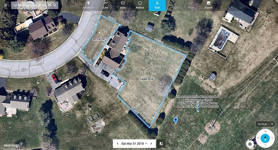
Nearmap high resolution aerial maps allow lawn and landscape professionals to see the details without having to travel on site. Here’s a recent aerial image captured on January 15th from Durham, NC:
Anyone developing a quote for service could zoom in and assess the quality of the landscape. They could measure areas, exclude beds, hardscapes, driveways and arrive at a precise estimate for services
The examples above are aerial maps taken near Boston, MA in the fall of 2016 and then again in the fall of 2017 – for the exact same property. Notice the difference in the quality of the lawns in the center and the lower right. Your services have worked well leading to high levels of customer satisfaction. In cases when you risk someone “churning” because they claim you have not improved the lawn, you can use the Nearmap historical archive to clearly demonstrate the progress you are making.
A cold, snowy winter is behind us. It’s time to plant, time to grow. There’s nothing like freshly mulched beds, precise edging and a lush green lawn. That’s what customers are looking for and now have the technology tools of the trade to build your company, win business faster and retain customers. Now you have the means to create that breathtaking landscape using a virtual set of aerial maps and truth on the ground. Transform the way you work with Nearmap high resolution aerial maps.


