From maps to action: Celebrating GIS Day
Nov 2025
GIS Day serves as a dynamic platform where professionals, educators, students, and businesses demonstrate real-world applications of geographic information systems.
Nov 2025
)
Every November, thousands of professionals, students, and technology enthusiasts unite to recognize the importance of geographic information systems (GIS). From the navigation app guiding your morning commute to the city planning initiatives reshaping entire communities, GIS technology powers decisions that impact our daily lives.
GIS Day recognizes how these systems transform raw spatial data into actionable intelligence, driving better outcomes across countless industries. And at the heart of every powerful GIS application? High-resolution aerial imagery and property intelligence that bring spatial data to life with remarkable clarity and precision.
The story behind GIS Day
GIS Day officially launched in 1999 through an initiative led by Esri, with significant input from company president and co-founder Jack Dangermond. Inspired by activist Ralph Nader’s vision for making geographic education accessible to everyone, this celebration occurs annually on the third Wednesday of November — strategically positioned during Geography Awareness Week to maximize its educational impact.
Today, GIS Day serves as a dynamic platform where professionals, educators, students, and businesses demonstrate real-world applications of geographic information systems. These showcases span diverse sectors, including environmental monitoring, urban planning, public health analytics, logistics optimization, and emergency management.
The celebration emphasizes spatial thinking, which is the practice of combining geographic context with data analysis to identify patterns, address challenges, and inform strategic decisions.
A global phenomenon
What started as a U.S.-based initiative has evolved into a worldwide celebration. Educational institutions, libraries, and government agencies across multiple countries organize events, workshops, and demonstrations to engage their communities with spatial technologies.
The digital conversation is equally global. Organizations worldwide use #GISDay to share their activities and insights, creating a connected global dialogue that spans time zones. Participants exchange knowledge, celebrate spatial innovation, and inspire the next generation of GIS professionals.
The celebration offers remarkable flexibility. An Esri resource provides “99 ways to celebrate GIS Day,” demonstrating the creativity possible within this framework. Activities range from classroom demonstrations to social media campaigns, allowing organizations to tailor their participation to their specific audiences and objectives.
The importance of GIS
Geographic information systems operate behind the scenes in countless daily activities. When municipal planners determine optimal locations for parks, transit routes, or flood management infrastructure, GIS technologies provide the analytical foundation for these critical decisions.
Environmental conservation efforts rely heavily on GIS capabilities to map critical habitats, monitor deforestation rates, and assess environmental changes over time. Urban planning applications include mapping utility networks, transportation systems, and tracking land-use modifications with precision.
But GIS represents far more than cartography. It’s the powerful intersection of data analysis, geographic context, and strategic insight.
An example of GIS in action could be local government officials using it to visualize overdue sidewalk repairs by layering datasets containing maintenance history, pedestrian traffic patterns, and current imagery. This comprehensive spatial analysis enables data-driven resource allocation and prioritization decisions that directly impact community safety and accessibility.
)
A foundation of high-resolution aerial imagery
While GIS Day celebrates the power of spatial data analysis, effective geographic information systems depend on accurately detailed visual information. This creates a powerful connection between advanced aerial imagery technologies and the spatial intelligence they enable.
Capturing reality with precision
Founded in 2007 in Australia, Nearmap has grown to serve the United States, Canada, Australia, and New Zealand. The company operates with the clear mission of making ground truth instantly accessible. This empowers governments, businesses, and communities to plan, build, and respond with confidence.
Nearmap maintains a vertically-integrated approach — from proprietary camera systems through processing and delivery — ensuring consistent image quality, reliability, and performance standards. This comprehensive control over the entire workflow delivers dependable results for critical applications.
Advanced imaging technology
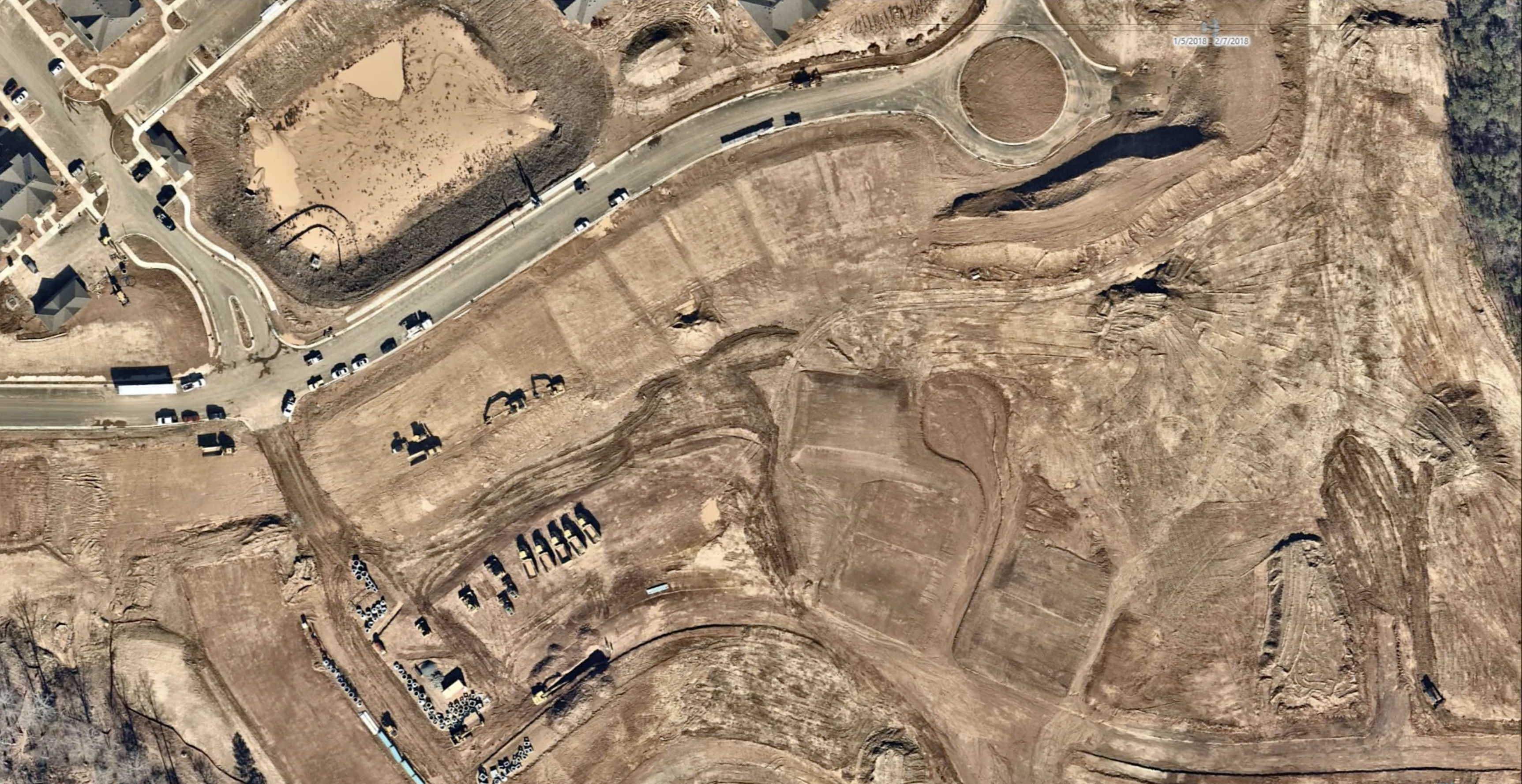
Nearmap uses proprietary, patented camera systems mounted on fixed-wing aircraft to capture high-resolution aerial imagery with frequent update cycles. This approach delivers typical resolution of 5.8 to 7.5 centimeters per pixel in urban areas — sufficient detail to detect features, vegetation changes, and surface modifications that satellites can’t match.
Regular coverage cycles ensure current data instead of outdated information. This frequency advantage is vital for applications requiring change detection, project monitoring, and rapid response capabilities.
From imagery to intelligence
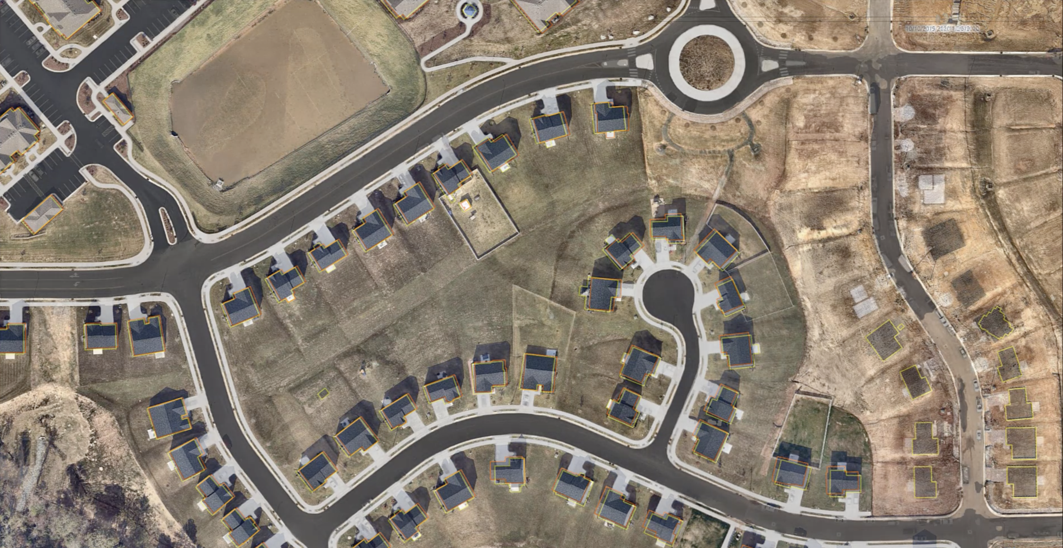
Nearmap does more than imagery. AI transforms our raw imagery into structured datasets by identifying and cataloging objects: buildings, trees, driveways, solar panels, construction sites, and more. These analytical products integrate directly with GIS platforms like Esri ArcGIS, fueling rapid spatial analysis and comprehensive change detection workflows.
This integration supports enhanced decision-making across multiple applications, including property condition assessments, infrastructure mapping, emergency response zone planning, and regulatory compliance monitoring.
Why this connection matters
GIS Day spotlights the critical role of spatial thinking in modern problem-solving, while advanced imagery technologies like Nearmap provide the visual and analytical foundation that makes this thinking possible. Without accurate, current imagery, GIS remains theoretical. Comprehensive aerial data supplies the contextual foundation that transforms spatial concepts into practical solutions.
The combination of imagery, analytics, and GIS technologies converts location questions into strategic insights, demonstrating how visual intelligence enhances spatial understanding and drives real-world impact.
Facts worth knowing
Nearly 25 years of celebration: The inaugural GIS Day occurred in 1999, establishing a quarter-century of continuous community engagement.
Massive coverage area: Nearmap captures millions of square miles of aerial imagery annually, covering 87% of the U.S. population. This extensive coverage supports thousands of government agencies, utilities, and organizations in making confident, data-driven decisions.
More than imagery: Nearmap technology extends far beyond traditional aerial imagery. AI-enhanced imagery processing enables automatic tracking of features like roofs, vegetation, and site changes, providing analytical capabilities that support complex spatial workflows.
Open to everyone: GIS Day welcomes participation from diverse audiences. Students, hobbyists, and professionals across industries are encouraged to explore, map, visualize, and share their spatial stories and applications.
Where intelligence meets impact
GIS Day represents more than appreciation for digital cartography or geographic education. It celebrates how spatial thinking, property intelligence, and comprehensive data analysis actively shape our world.
City planners can determine optimal bike lane placement. Environmental analysts can track deforestation patterns. And insurance adjusters can assess roof damage through aerial imagery analysis. These applications are just a fraction of what makes GIS invaluable.
Behind these diverse applications lies the foundation of quality data and imagery — captured, processed, and delivered by advanced technology platforms that transform raw spatial information into actionable intelligence. When you engage with GIS Day activities or explore spatial applications, consider the complete workflow. This includes data capture, spatial processing, analytical enhancement, and strategic application.
The power of geographic information systems is full realized when integrating technology, analysis, and insight. GIS Day is your invitation to explore this comprehensive approach. Because it’s how we understand, share, and apply spatial intelligence to address real-world challenges with confidence and precision.
Ready to see how high-resolution imagery enhances your GIS capabilities? Discover how Nearmap property intelligence can transform your spatial analysis and decision-making processes.