Building a water-secure future
Discover how high-res aerial imagery and AI insights are helping water managers plan better, act faster, and enhance water security for communities — now and for the future.
)
Executive Summary
Australia faces a future defined by extremes: longer droughts, fiercer floods, and rising unpredictability. Traditional methods of water management can no longer keep pace.
This white paper explores how property intelligence — combining high-resolution aerial imagery, AI, and geospatial technology — is helping water managers build resilience. With real-world examples from Melbourne Water, Disaster Relief Australia (DRA), Sydney Water, and A1 Services, we show how faster responses, smarter planning, and better environmental stewardship are already happening.
Australia’s water future is ours to shape. The decisions we make today, powered by smarter insights, will shape a stronger, more resilient tomorrow.
Managing water in a land of extremes
Australia’s water story is one of extremes. It’s a continent shaped by droughts that linger for years and floods that arrive in days. In 2024, the nation recorded 596 mm of rainfall—28% above the 1961–1990 average—making it the eighth-wettest year since records began in 1900. Yet just a few years earlier, dams were running dry, and farmland was parched under the pressure of relentless drought. This is the reality for water managers on the driest inhabited continent on Earth, where rain is scarce, unevenly distributed, and increasingly unpredictable.
Climate change is now intensifying this variability, producing more extreme droughts and floods, and as weather patterns shift, historical data is no longer a dependable guide. Climate projections for Australia suggest a future of more intense storms alongside prolonged dry spells—a combination that fuels both flash floods and severe drought. Confronting these twin threats calls for smarter tools to build more adaptive resilience strategies that move beyond the old playbook and prepare us for what’s ahead.
So, how do we future-proof our systems in the face of such uncertainty? One powerful answer lies not beneath the surface — but above it.
Property intelligence in water management
Getting ahead of drought
Aerial and satellite imagery now track subtle changes in vegetation health, soil moisture, and water body levels across vast regions. Near-infrared imaging, for example, can highlight water stress before it becomes visible to the human eye.
Historical and frequently updated imagery can help agencies compare imagery over time to detect receding wetlands, emptying reservoirs, or even creeping desertification. It’s not just about watching a crisis unfold; it’s also about acting early to reduce the severity of environmental and infrastructure risks.
Tools like the National Drought Map combine these signals into one platform, allowing policymakers to quickly understand where water stress is most severe—and respond accordingly.
)
Customer highlight
Real-world impact: Melbourne Water
Melbourne Water uses Nearmap AI-driven insights to protect critical waterways and support conservation projects like saving the platypus.
Responding faster when floods hit
When floods arrive, the clock starts ticking. Understanding where water will go and how fast is critical. That’s where 3D digital terrain models come in. These tools allow hydrologists to simulate flood scenarios based on real-world coordinates, creating topographical predictions of how water will move across the land. In the 2022 floods, post-event aerial imagery from Nearmap helped authorities find isolated towns, coordinate evacuations, and prioritise aid — within days.
When emergency services have immediate access to updated imagery, they can allocate resources where they’re needed most, ultimately saving lives and reducing damage.
)
Customer highlight
Real-world impact: Disaster Relief Australia
Disaster Relief Australia (DRA) used Nearmap imagery to speed up damage assessments and get help to communities who needed it fast.
Smarter oversight of infrastructure
Australia’s water infrastructure stretches across remote, rugged country. Dams, pipelines, and pumping stations often span thousands of kilometres across remote terrain. Regular inspection is costly and logistically challenging. But with frequent high-resolution aerial surveys, water utilities can now monitor much of this infrastructure remotely.
Now, utilities asset managers can spot a blocked spillway, a leak, or vegetation creeping onto pipelines without even setting foot on site. Early action means fewer failures, lower costs, and better outcomes for the environment.
Frequent aerial updates allow asset managers to detect problems before they escalate. It also enables smarter prioritisation of maintenance resources, preventing costly downtime and improving public trust in essential services.
)
Customer highlight
Real-world impact: Sydney Water
Sydney Water’s “Spatial Hub” uses Nearmap data to monitor thousands of kilometres of assets, helping to streamline asset maintenance processes.
Designing water-resilient cities
With nearly 20 million more people expected to call Australia home in the next 30 years, cities must be ready. That means building water resilience into every plan.
AI-powered surface classification helps planners figure out where water will go, where green infrastructure like bioswales and rain gardens will have the most impact, and how to better manage stormwater from the start.
Modern city planning isn’t just about managing growth — it’s about making sure that growth is sustainable, smart, and safe. Property intelligence ensures that new developments strengthen, rather than strain, urban water systems.
Bottom line: Smarter cities mean fewer floods, lower insurance premiums, and greener neighbourhoods.
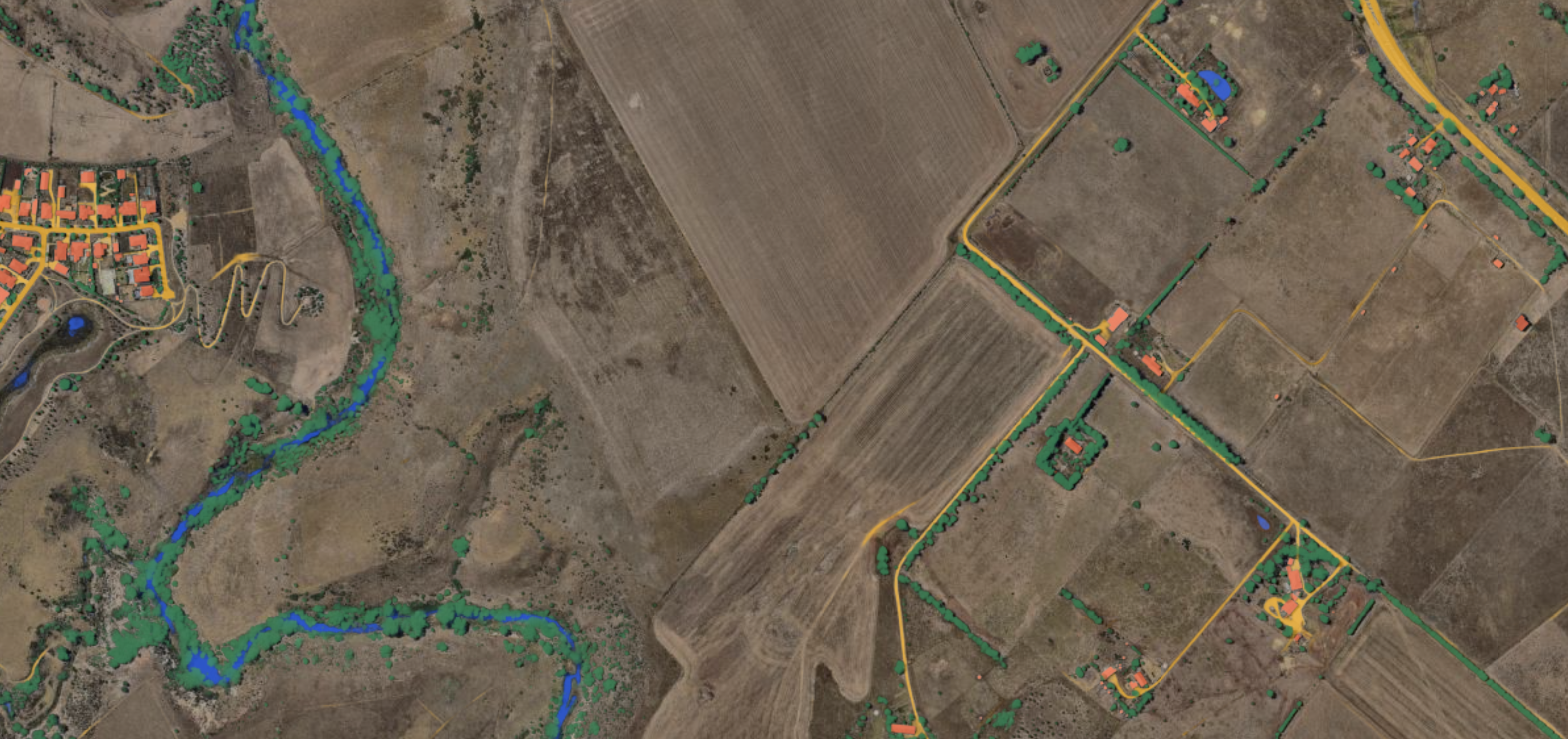
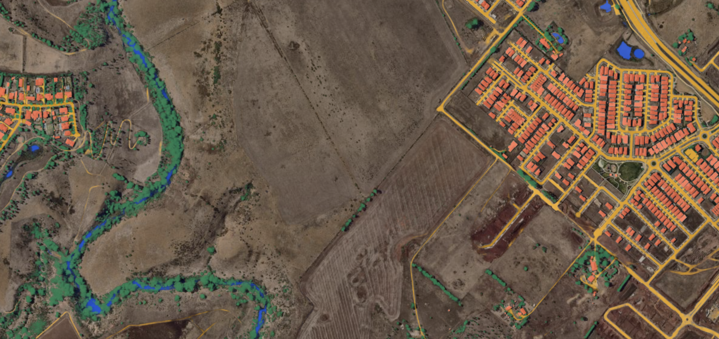
AI layers show growing development
Sunbury, VIC
High-resolution imagery: The new planning baseline
Satellite imagery can be useful as long as you’re not after sharp clarity or detailed measurability. However, when details matter, you need a closer view. Flying closer to the earth, Nearmap uses fixed-wing aircraft to capture sharp, detailed images several times a year – down to a resolution of 5–7cm GSD (Ground Sampling Distance).
That kind of clarity lets planners track land-use changes, engineers model catchment areas in 3D, and asset managers spot early signs of erosion. Frequent updates also allow trends to be spotted quickly, informing better decision-making across agencies.
Result: Better data, better plans, fewer surprises.
AI and automation: Turning imagery into intelligence
Manually mapping flood zones, tracking new developments, or monitoring riverbanks used to take weeks. Now, AI can surface those insights in minutes.
Nearmap AI automatically detects over 130 features — from roads to rivers — giving decision-makers a clear, updated view without the heavy lifting.
With scalable AI detection, organisations can manage larger areas without stretching their teams thin, delivering greater impact with fewer resources.
)
Responding to disaster with eyes in the sky
When disaster hits, speed matters. During the April 2025 floods in outback Queensland, the Nearmap ImpactResponse solution delivered post-event aerial imagery to emergency teams and government agencies within days. That imagery helped decision-makers triage the response, target recovery resources, and assess damages before the waters had even fully receded. This kind of rapid aerial insight could be combined with flood forecasting models and live sensor data to update emergency response plans as events unfold dynamically. It’s not just about responding faster—it’s about building systems that can adapt in real-time.
Result: Faster decisions. Smarter recovery. Better outcomes.
)
Customer highlight
Real-world impact: A1 Services
A1 Services used Nearmap AI to prioritise flood recovery work after major events, helping communities rebuild faster.
The bigger picture: A digital twin of Australia’s water system
The most exciting development on the horizon is the creation of digital twins—dynamic, spatially accurate models of real-world water systems. These aren’t just maps. They’re living models that bring together aerial imagery, real-time sensor data, climate forecasts, and asset information.
With a digital twin, a water authority could zoom into a specific suburb to check reservoir levels, rainfall history, and infrastructure conditions—all at once. They could run “what-if” scenarios, like simulating a drought 20% worse than the last, or mapping how a storm surge would impact coastal infrastructure.
This future isn’t science fiction. Many elements—like Sydney Water’s spatial systems and the National Drought Dashboard—are already in place. What’s needed now is integration: systems that talk to each other, teams trained to use them, and policies that prioritise data-led decision-making.
What it means: Predictive planning, smarter investment, and faster responses to evolving threats.
Water resilience is a team sport
Water resilience isn’t the responsibility of any single agency. It cuts across urban planning, emergency services, utilities, agriculture, and environmental stewardship. Geospatial tools provide a common language that can unite these groups around the same data and the same goals.
When everyone’s working from the same map—whether it’s a floodplain risk assessment or a drought forecast—coordination improves. Decisions align. And communities benefit.
When we all see the same picture, we can act together.
)
Why now?
Australia’s challenges around water are not “someday” problems. They’re here today, getting bigger and moving faster. The cost of delay — in lost crops, damaged cities, or broken ecosystems — is rising.
The good news? The tools to address these challenges exist right now. High-resolution aerial imagery, AI analytics, and property intelligence platforms are available, proven, and already helping organisations build resilience. Choosing to invest in these technologies isn’t just smart; it’s urgent.

See more. Act faster. Build resilience.
Australia’s water future will be shaped by extremes. But it will be secured by insights and strategic action.
High-resolution aerial imagery. AI-driven analysis. Integrated geospatial platforms. These aren’t just nice-to-haves anymore — they’re essential.
Nearmap is proud to work alongside leading organisations to make better, faster, more confident water and asset management possible.


Ready to see what's next?
Seeing clearly—before the next drought or flood—might just be the most powerful step we can take toward a water-secure future. Start your journey with us.
Get in Touch