How claims teams used Nearmap AI after the Spokane fires
Nearmap AI found 853 buildings destroyed in the Spokane fires. Here’s what claims teams saw first.
)
On August 1, 2026, three fires broke out around Spokane, Washington. Within hours, P&C insurance carriers writing policies inside those perimeters faced the question every fast-moving bushfire creates: which properties are still standing?
Answering it used to mean waiting for FNOL and sending people in. After the Old Trails, Autumn Lane, and Fairview fires, it took 48 hours.
Speed is step one
The fires started at approximately noon PDT. Nearmap aircraft were airborne at 5:07 p.m. PDT the same day, and the first image of the affected area was captured at 6:32 p.m., under seven hours from ignition. The first imagery was published at 8:52 p.m. PDT on August 2.
The first pass caught the event mid-run: fire spreading house to house, whole blocks alight, and bright red lines of retardant separating the homes that burned from the ones that survived.
Damage-detection capture followed on August 3 between 2:00 p.m. and 3:40 p.m. PDT, covering 471 square kms and 100% of the mapped perimeters of all three fires.
Bushfire damage moves faster than claims volume builds. Getting complete overhead visibility across every perimeter while inbound FNOL is still arriving is what separates managed triage from reactive dispatch.
Bushfire damage concentrates, and the pattern is consistent
Nearmap AI initially examined approximately 164,543 mapped structures across the surveyed area. After filtering out sheds, secondary structures, and lower-confidence detections, 102,532 buildings larger than ~9 square metres were included in the refined analysis. Inside the three fire perimeters, 2,576 buildings larger than 37 square metres were assessed for damage.
Spokane fires, by the numbers
Fire | Buildings analysed (over 37 sq m) | Visible damage | Completely destroyed |
|---|---|---|---|
Old Trails | 1,900 | 630 (33%) | 623 (32%) |
Autumn Lane | 497 | 172 (34%) | 168 (33%) |
Fairview | 179 | 67 (37%) | 62 (34%) |
Combined | 2,579 | 869 (33%) | 2,579 |
Across the wider surveyed area, 1,138 structures larger than 100 square feet showed visible damage. Of the 869 primary structures with visible damage, 853 were completely destroyed — 98%.
)
The purple outlines show where AI detected that properties that were completely destroyed during the Spokane fires.
Damage from a hail or wind event grades across a severity range and adjusters are needed to sort it. In these fires, a property inside the perimeter was either untouched or a total loss, with very little in between. The damage rate held within four points across three separate fires, which means the proportion of total losses inside a perimeter is predictable enough to plan adjuster capacity against.
That visibility is actionable in a specific way. Total losses can be identified and fast-tracked before they are reported. Insurance adjusters can be routed to the small number of partial-damage properties that genuinely require an inspection. The rest of the portfolio inside the surveyed area can be cleared remotely.
The before image is half the claim
Claims teams need a before-and-after comparison from the same capture program, processed to the same standard, for the most accurate assessment. The comparison is defensible.
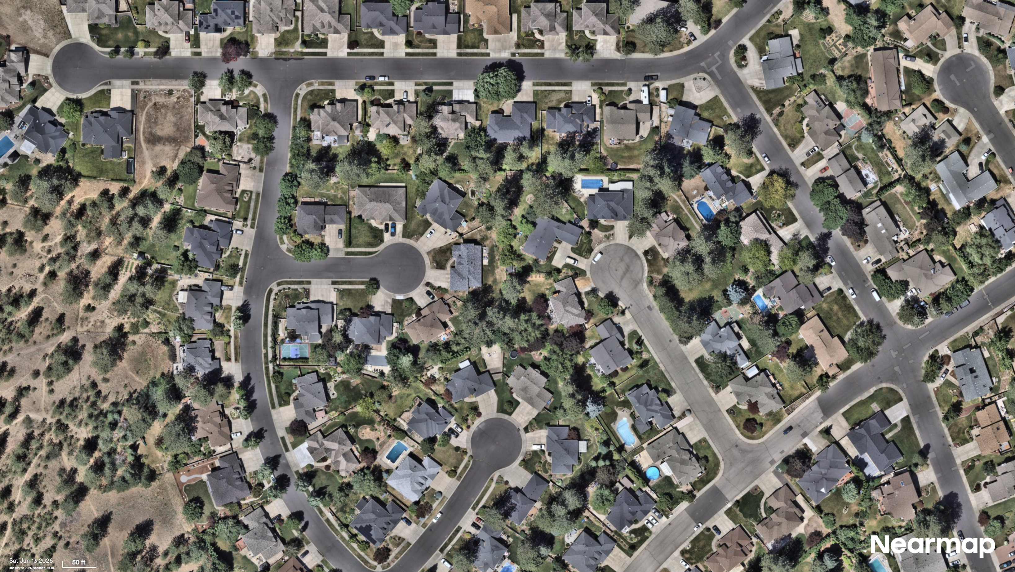
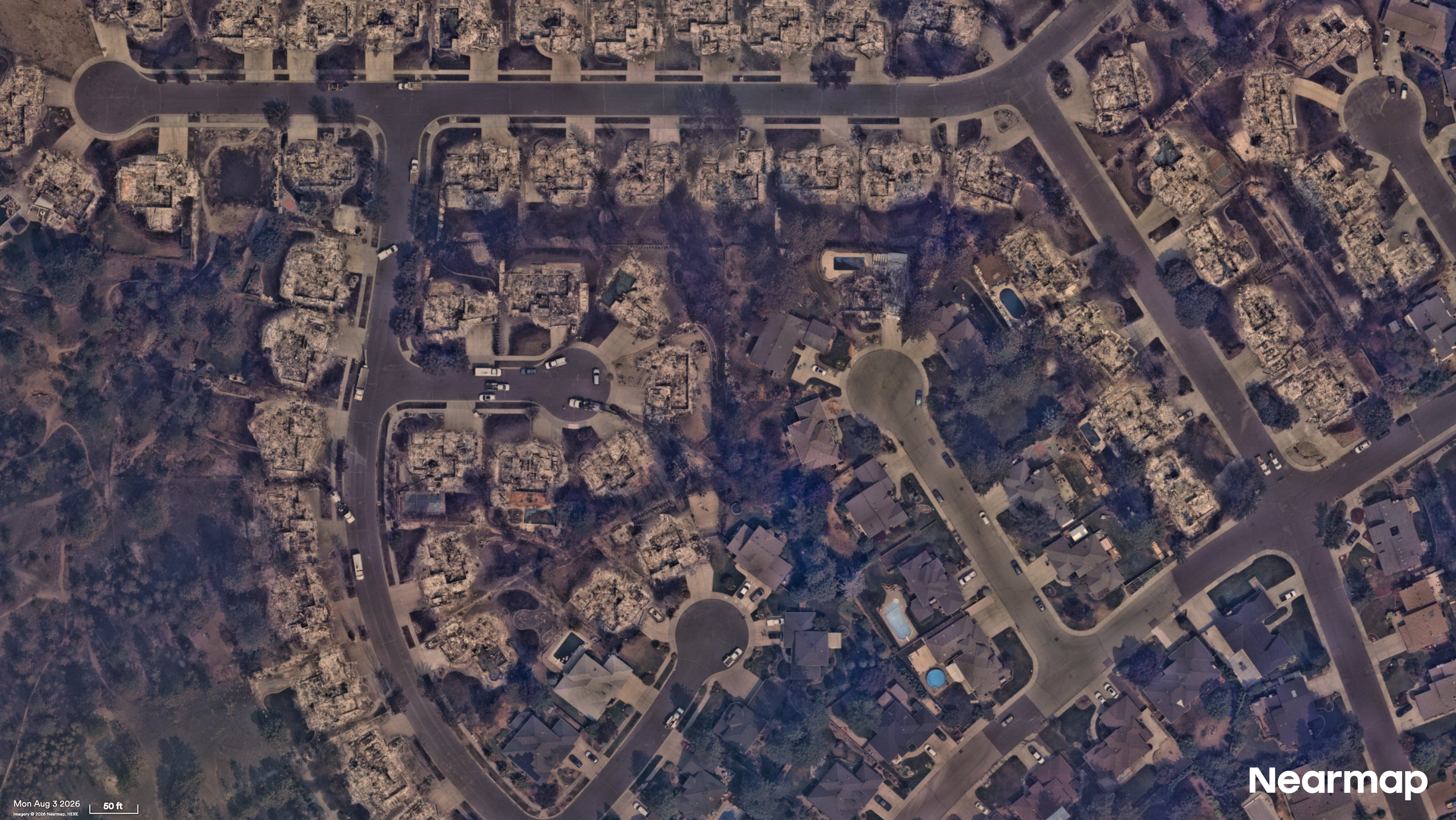
Bushfire claims raise the question earlier and more often than most perils: what was on this parcel before it burned? Total loss settlements depend on establishing the pre-event condition, footprint, and structure count of a property that no longer exists. When that evidence comes from a different source, a different resolution, or a different methodology, it creates an opening for dispute.
The same pre-event baseline supports reserving too. A structure documented as destroyed rather than estimated as at-risk guides the initial reserve, backing a calibrated decision instead of an exposure model output.
Scale is non-negotiable
The Spokane fires are a contained example of a challenge that plays out across entire counties during a bad fire season. The operational logic holds at any size. Claims teams that know where total losses are concentrated before adjusters deploy make better decisions about where those adjusters go. Teams that can produce a defensible pre-event record at the property level spend less time arguing about what was there.
Post-CAT claims response has historically been sequential. Wait for FNOL, dispatch, assess, settle. Aerial damage analysis at speed keeps the sequence and compresses the gap between the first step and the last.