Building smarter in 2026: Five companies leading with location intelligence
Dec 2025
Stephen Neale, Manager, Solutions Engineering, NearmapHow five organisations in ANZ are using geospatial data, AI and 3D modelling to cut costs, reduce risk and win more work.
Dec 2025
Stephen Neale, Manager, Solutions Engineering, Nearmap)
Western Sydney International Airport
The numbers are hard to ignore. According to Bluebeam’s AEC Technology Outlook 2026, 84% of Australian firms plan to boost their technology investment this year. Nearly half of early AI adopters have already gained back over 500 hours on key project tasks. Yet 89% of firms still aren’t fully digital across every stage of a project.
A recent Engineers Australia survey paints a similar picture. The geospatial technologies most commonly used by Australian engineers are Digital Elevation Modelling for terrain analysis (35%), line-of-sight analysis to assess site accessibility (34%), and 3D models integrated with BIM for more accurate project designs (29%). But over a quarter of engineers still aren’t using geospatial technology in their design and engineering processes at all.
That gap between ambition and execution represents both a challenge and an opportunity. The firms pulling ahead aren’t waiting for perfect conditions. They’re embedding location intelligence into their workflows now, using frequently updated aerial imagery, AI-powered feature detection and 3D reality models to make faster, more confident decisions.
Here’s how five organisations in Australia are doing it.
Arcadis: Winning complex infrastructure projects with geospatial intelligence
When Arcadis took on Western Sydney’s Nancy-Bird Walton International Airport, one of the largest construction projects Sydney has seen in decades, accurate data wasn’t a nice-to-have. It was essential.
The project involved moving more than 23 million cubic metres of earth and installing 70 kilometres of drainage lines. With bulk earthworks of that scale, updated digital terrain was critical to planning work packages and avoiding costly surprises.
“We used Nearmap to help us develop the design, and also the final documentation. That was really important,” says Steven Coyle, Digital Lead for Australia at Arcadis. “The amount of bulk earthworks that went into that project was enormous, probably one of the biggest projects in Sydney in a long time.”
The geospatial data helped Arcadis optimise early designs, communicate with stakeholders through immersive visualisations, collaborate remotely with the client and engineering teams, and ensure all plans reflected real-world conditions. The result: fewer site visits, faster decisions, and greater confidence in the engineering from day one.
At Fisherman’s Bend Innovation Precinct, Arcadis took a similar approach, using Nearmap 3D reality models to visualise sheet-piling construction sequencing relative to existing buildings, structures and terrain. The team modelled everything from exclusion fencing and groundwater pump sites to ingress points and stretcher provisions.
“We worked out that this probably saved us around 60% of time rather than using other methods,” says Coyle. “2D construction sequencing, pages and pages of reports... real-life context is super important.”
It’s a compelling efficiency gain in an industry where, according to research from FMI and Procore, 70% of rework is attributed to design errors, 52% stems from inaccurate data and miscommunication, and rework alone accounts for 19% of total project costs.
)
Badgerys Creek, NSW
Jemena: Turning pixels into prevention
For utilities, the stakes extend beyond project timelines. They’re managing critical infrastructure where mistakes can be dangerous and expensive.
At Jemena, location intelligence has become central to both safety and cost management. David Morgan, Geospatial Operations Lead, describes a recent case where a homeowner had built a structure directly over a high-pressure gas main without approval.
“By using the timeline feature in Nearmap we identified when it was built and confirmed there was no approval in place,” Morgan explains. “The owner removed the structure, reducing the hazard, and Jemena avoided significant relocation costs.”
That same platform now supports AI-powered analysis of vegetation patterns and encroachments, helping Jemena prioritise maintenance more accurately and reduce the need for physical site visits.
“Nearmap helps us see risks and issues early,” says Morgan. “That visibility lets us act sooner and optimise our field workforce planning.”
Melbourne Water: Tracking environmental change at scale
Urban development creates ongoing pressure on waterways. Native species like platypus and rakali are particularly sensitive to changes in stream health, making early detection of problems essential.
Melbourne Water uses Nearmap aerial imagery and AI-derived data to monitor how impervious surfaces like rooftops, driveways and roads are changing across greater Melbourne. That data feeds into their Habitat Suitability Models, helping predict where stormwater runoff will increase and prioritise interventions before problems escalate.
“It was formerly taking years to get quite an average product. Now with the Nearmap data we’ve got it down to a couple of months for a quality product. It’s been transformative for us,” says Al Danger, Senior Asset Manager, Waterways at Melbourne Water.
The combination of frequently updated imagery and AI-powered surface analysis gives the organisation a clear picture of urban change over time, supporting better planning decisions and more targeted investment in waterway health.
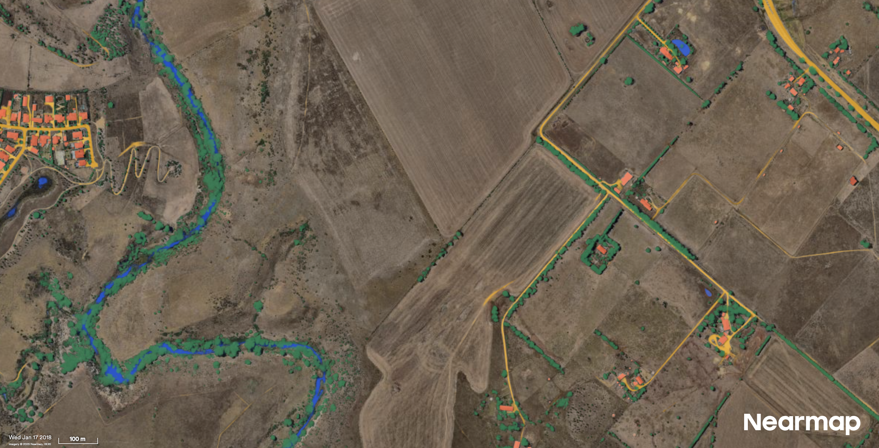
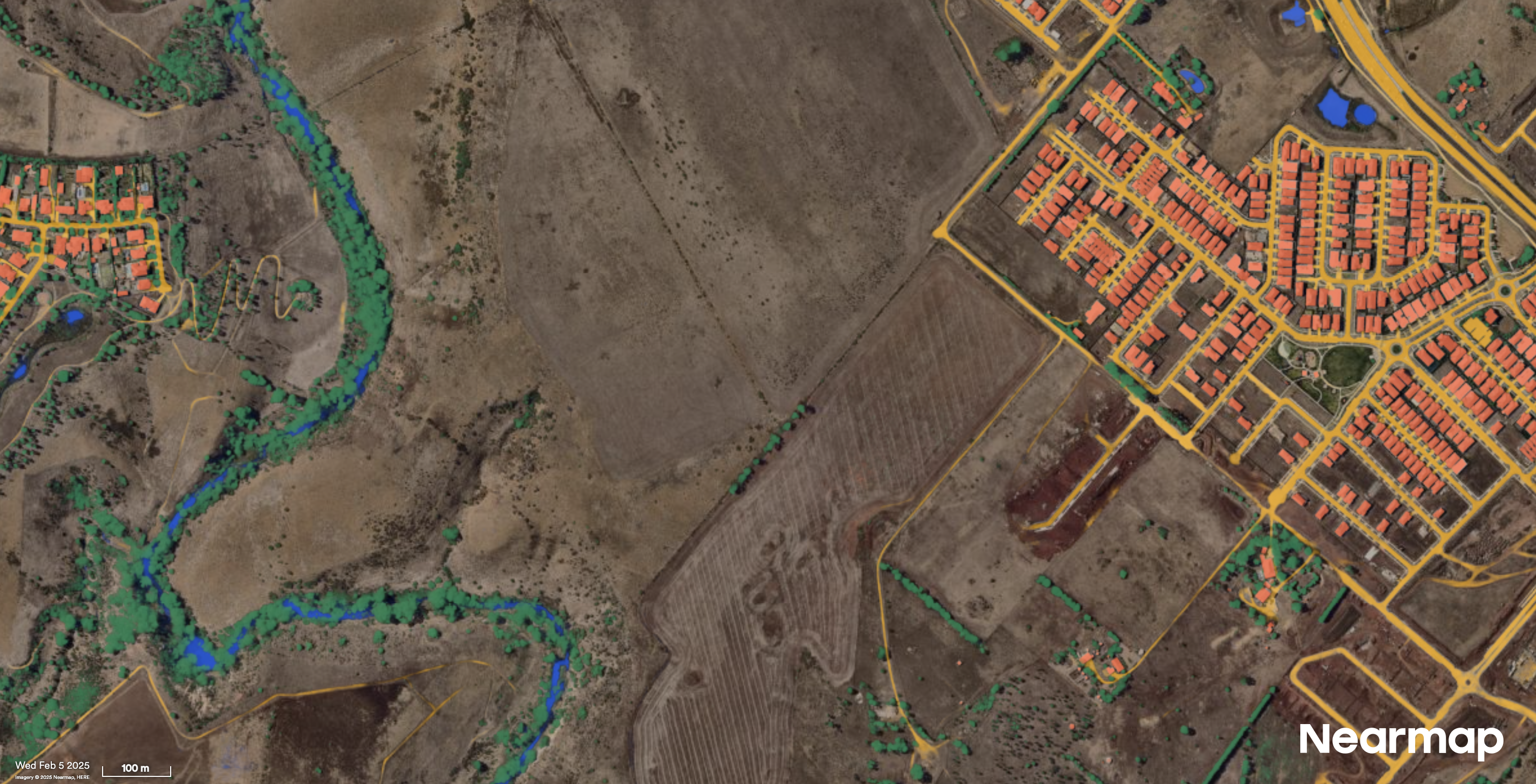
Sunbury, VIC
Simonds Homes: Helping clients see what they can’t
Simonds Homes has spent 75 years helping Australians build quality, affordable homes. For New Home Specialist Sid Lakhina, giving clients the full picture before they commit is essential.
In one case, a client arrived excited about a property they’d identified for a knock-down rebuild. All the standard, publicly available data seemed to justify their enthusiasm. But Nearmap imagery revealed the property boundaries intersected with several mature trees and dense vegetation, issues that could have caused plan alterations and a budget blowout.
“Instead of days, we’re talking about a few minutes,” says Lakhina. “And with some insights the client wouldn’t have necessarily been able to understand themselves.”
The team uses Nearmap to define property boundaries, model overshadowing at different times of day, and track project progress through the timeline tool. Clients are often surprised by how current the imagery is.
“People will often say ‘oh that is my car... that is the pool that we’ve just put in’. The most common feedback I get is: how is it so recent... what do you use?”
For Lakhina, the value is clear: “This data helps us give value to clients, and that leads to the decision making.”
)
Angle Vale, SA
ConnectEast: The paperless route to toll road maintenance
ConnectEast operates EastLink, Melbourne’s 39-kilometre toll road connecting the eastern and south-eastern suburbs. Managing a motorway of that scale, with its constant traffic flows and strict safety requirements, demands precise coordination and up-to-date information.
The company has moved away from paper-based asset management to a digital-first approach, using Nearmap aerial imagery to monitor infrastructure, track changes along the corridor, and verify that adjacent developments comply with requirements.
“With new developments, we can view Nearmap to see change over time and ensure developers are adhering to measurements outlined in development plans,” says Emma Georgiou, Program Management Office Scheduler at ConnectEast.
That visibility extends across the network. By comparing current and historical imagery, the team can identify changes to the road environment, plan maintenance more effectively, and coordinate works without relying solely on physical inspections. For an asset that operates around the clock, reducing the need for on-site visits while maintaining oversight is a significant operational advantage.
The desktop dividend: rethinking site visits
Across these five organisations, a common pattern emerges: location intelligence is fundamentally changing when and why teams need to be physically on site.
This isn’t about eliminating site visits entirely. Boots on the ground will always matter for construction, utilities and infrastructure. But the economics shift dramatically when desktop analysis can handle the routine work, freeing field teams for tasks that genuinely require their presence.
The pattern is consistent across the organisations featured here. Whether it’s handling the vast majority of site assessments from the desktop, dramatically reducing time spent on construction sequencing by working in 3D, compressing days of due diligence into hours, or monitoring an entire corridor without relying solely on physical inspections — the outcome is the same. Fewer unnecessary trips. Faster decisions. More capacity for work that genuinely requires boots on the ground.
For organisations managing dispersed assets or evaluating dozens of sites per week, that efficiency compounds quickly. Fewer windscreen hours. More capacity to focus skilled staff on complex, high-value work.
Site visits used to be how you gathered information. Now they’re how you act on it.
)
The technology enabling this shift
What’s changed? The barrier to accessing location intelligence has dropped dramatically.
Nearmap captures high-resolution aerial imagery with a ground sampling distance resolution of 5.5cm–7.5cm per pixel, across more than 95% of Australia’s population, up to six times per year. That imagery is processed and available in the cloud within days of capture, ready to view through a web browser, integrate via API, or stream directly into GIS and CAD platforms like Esri ArcGIS, Autodesk and Bentley Systems.
Beyond raw imagery, AI-powered feature detection can now automatically identify more than 130 different attributes: building footprints and roof materials, vegetation coverage, solar panels, construction sites and more. Digital Surface Models and Digital Terrain Models provide precise elevation data for drainage planning, volume calculations and slope compliance.
For organisations managing large asset portfolios or complex projects, this combination of currency, coverage and intelligence changes what’s possible from the desktop.
)
Preparing for 2026 and beyond
The Bluebeam research points to an industry at an inflection point. Firms are investing in technology, but many are still evaluating how to realise its full potential.
The organisations leading the way share a common approach: they’re using location intelligence to reduce uncertainty, accelerate decisions and avoid the costly rework that erodes project margins.
Whether it’s Arcadis saving 60% of time on construction sequencing, Jemena identifying infrastructure risks before they become emergencies, or Melbourne Water compressing years of analysis into months, the pattern is consistent. Better data leads to better outcomes.
For firms looking to improve efficiency, grow their pipeline, and drive profitability in 2026, the path forward is clear. The imagery, the AI, and the integration capabilities exist today. Those who adopt them now won’t just work more efficiently — they’ll be winning work while others are still evaluating their options.
Ready to gain a competitive edge?
Bring your challenge to us and we’ll provide tailored advice for how you could use aerial imagery and actionable AI data to build smarter in 2026.
Some of the technology solutions and products mentioned in this article may not currently be available in your region.
)
About the author
Stephen Neale leads the Nearmap solution engineering team for Government & Commercial across Australia and New Zealand, where he helps organisations harness geospatial technology, AI, and automation to transform how they work. With a Master’s in GIS and Remote Sensing and twenty years of experience in geospatial science, he’s developed solutions spanning vehicle navigation, autonomous driving, 3D modelling, and aerial imagery. Stephen is driven by a simple mission: helping teams unlock smarter, faster, and more connected ways of working through location intelligence.