Nearmap Announces Agreement to Acquire Betterview

Learn More
X
Hurricane Idalia before and after pictures
Insurance Claims

Simplify and Expedite Claims Workflows

Nearmap aerial intelligence is the key to making data-driven decisions that speed your claims workflows and your policyholders’ experience post-catastrophe.

Aug 2023 | Hurricane Idalia Damage, Steinhatchee, FL

Transform Post-catastrophe Policyholder Support

When disasters happen, time is of the essence. Details matter. Respond more effectively to the catastrophes that affect your policyholders with the post-catastrophe solutions from Nearmap. Our post-catastrophe imagery, united with our AI-derived property damage and condition data, empowers you to better support your customers and process claims more efficiently.

Elevate Your Disaster Response

Respond More Effectively

With sharper and faster property intelligence and insights

Improve Customer Experience

By quickly responding with critical resources and rapid relief

Process Claims More Efficiently

By improving decisions and streamlining workflows

After a hurricane, it’s like a warzone. We can’t get in there by vehicle. Nearmap imagery allows us to see the damage from above. We can view entire neighborhoods to see how hard they were affected; if powerlines are down and start to determine where to send resources.
Noel Bunol, Executive VP, Gulf States Insurance

Unlock Powerful Property Insights

Boost your disaster readiness with Nearmap pre- and post-catastrophe imagery and AI tools. Make time-sensitive decisions confidently with data and our coverage of over 100 million parcels annually.

Nearmap
ImpactResponse

Catastrophic Event

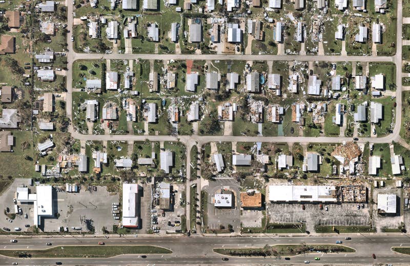
In the critical aftermath of a disaster, every second counts. Nearmap ImpactResponse makes those seconds count for you and your policyholders. This solution offers rapid collection of high-resolution aerial imagery, often delivered within 24 hours of a catastrophe's landfall. We consistently provide the sharpest post-catastrophe imagery on the market, delivering images at sub-3” per pixel. This level of detail not only ensures accuracy but also accelerates the process of claims management.

Nearmap
ImpactTriage AI

First Notice of Loss

ImpactTriage AI leverages advanced machine learning algorithms to classify property damage into both 3-tier and 5-tier FEMA classifications. This quick and accurate stratification enables you to prioritize responses based on the severity of damage and the urgency of needs. With ImpactTriage AI, you're not just managing disaster response—you're transforming it with intelligence and foresight, providing your policyholders with the service they need during their times of need.

Nearmap
ImpactAssessment AI

Adjust and Settle

Rather than relying solely on traditional assessment methods, ImpactAssessment AI facilitates detailed examinations of property conditions post-disaster. You get a clear, up-to-date view of property damage which greatly improves the speed and accuracy of claim settlements, while also mitigating the risk of fraud. This groundbreaking tool allows you to serve your policyholders with unparalleled efficiency and precision, ensuring you deliver on your promise to them when they need it the most.
hurricane, roof, lake charles, post-cat
Lake Charles, LA, U.S.

Join the Nearmap Revolution

Ready to redefine your decision-making process with the extensive aerial coverage, frequent updates, and innovation provided by Nearmap?

Get a Quote