Nearmap Announces Agreement to Acquire Betterview

Learn More
X
Nearmap AI location intelligence for aerial maps
Nearmap AI

Artificial Intelligence (AI) On-demand

Power your decision-making with Nearmap AI imagery and data — regularly updated, location insights extracted from high-resolution aerial imagery. Our up-to-date location intelligence is processed at scale and available via MapBrowser, PropertyVision, API and offline delivery.

Feb 2023 | Phoenix, AZ, U.S.
Automated insights you can trust
AI Layers showing tree overhang, solar panels and tall vegetation

Automated Insights You Can Trust

Our best-in-class AI imagery and data ensures superior feature extraction. Automate your insight-gathering to save hours every day — for insurance underwriting, claims processing, property appraisals, and solar design. Our content is date-stamped and verifiable against Nearmap aerial imagery.
Dig Deep with AI Layers

Looking to identify the latest construction activities? Want to inspect tree overhang? Need to identify properties without solar panels? Nearmap AI is made available as a series of AI packs covering different themes. There are 13 AI packs with nearly 50 data layers available to serve various needs.

AI Packs To Power Your Decisions

  • Building Footprints
  • Building Characteristics
  • Roof Condition
  • Roof Objects
  • Trampolines
  • Solar Panels
  • Swimming Pool
  • Surfaces
  • Surface Permeability
  • Surface Markings
  • Vegetation
  • Debris
  • Construction
Property insights from aerial imagery

High Quality Answers from High Quality Data

A growing list of AI Packs serves the different needs of your business. With content refreshed every time we fly, you can have confidence that your geospatial and location data is always up-to-date. Our feature attributes include confidence scores for the identified features, so you can adjust your models based on your requirements and tolerances. Not enough? Ensure the accuracy of the data with access to the source imagery.

High quality aerial data
AI Layers showing construction vehicles, buildings and sites

AI Vector and Location Data

Seamlessly switch between Vector and Raster layers, for a comprehensive view. Quickly pinpoint new opportunities based on specific criteria, evaluate site conditions, and expedite your workflows by filtering with confidence and fidelity scores. View your AI Packs via MapBrowser, PropertyVision, API, or order an offline dataset for use with leading GIS platform and workflow applications. No data team? No worries.

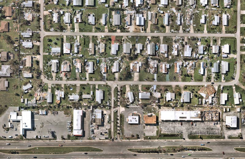
Powerful Property Insights for Catastrophe Response

When disasters strike and every second counts, accurate and actionable information is critical. The post-catastrophe solutions from Nearmap provide insurers with the best aerial imagery and AI-derived damage assessment data to support all stages of the post-catastrophe response and recovery process.

Learn More
Property insights for disaster response

Frequently Asked Questions

  • What is Nearmap AI Imagery and Data?

    Nearmap AI is our image and object recognition product which enables you to derive deeper insights of an area or parcel in seconds. Derived from our high-resolution vertical and oblique imagery, you can easily interact with the relevant AI Layers from MapBrowser. Or should you simply want to bring our AI-derived data to your workflow, you can download or use AI Feature API and integrate with your tech stack.

  • What are the features of Nearmap AI?

    Nearmap AI subscription unlocks two new features in MapBrowser: AI Layers, and AI Parcel Export.

    With View AI Layers, you can add a visual overlay on top of our imagery to allow you to focus on what you care about most. Some of our AI Packs will come with multiple attributes, so be sure to discuss your requirements with your account manager to see the full range of attributes available to you. Or check out our documentation on our Help Center.

    After checking out the AI Layers, you may want to export the content to integrate into your in-house GIS platform or some other workflow applications for data enrichment — that is where AI Parcel Export comes in. AI Feature API is also available for more technical use cases.

    To have access to AI Parcel Export, your organization must be subscribed to Nearmap AI which comes with a predetermined AI Parcel Export credit for self-service export. You will also need to have Nearmap AI permissions, which your account administrator can provide you with.

  • What are the AI Packs available now?

    Nearmap AI has been pre-processed at full resolution on our vertical imagery coverage and continues to be processed on every survey we fly from mid-2020 onwards. Historical data available on request. See below our growing list of AI Packs you can choose from:

    • Building footprints
    • Building characteristics (height & story attributes)
    • Roof characteristics
    • Vegetation
    • Surfaces
    • Swimming pools
    • Solar panels
    • Construction sites
    • Trampolines
    • and more

    For a full list of AI Packs and Layers, visit our Help Center.

  • What are the formats of your AI Parcel Export?

    Nearmap AI Parcels are exported as Rich Geospatial File and Spreadsheet File (.csv). At launch, the Rich Geospatial File is an AI Parcel Geopackage (.gpkg) but we may add new geospatial file formats over time. Visit our Help Center for more information.

  • Is the AI Feature API right for me?

    If you want to interact programmatically with our data to always get the latest content, you can clip out a small area of our AI vector content using the AI Feature API. With the latest data on a property sized Query AOI typically returned in a few hundred milliseconds, this is ideal for integration into customer facing workflows where seconds matter.

    We also recommend the AI Feature API for enterprise use, where massive throughput is required for regular bulk updates in an automated fashion. To learn more, visit our Help Center.

  • Do I need to have a Nearmap vertical imagery subscription to get access?

    Yes, Nearmap AI is a premium content type that empowers you to extract more actionable insights from our high-resolution aerial imagery. Our AI datasets are perfectly aligned to our imagery so you can verify content and see change over time. It’s a powerful combination which you must see for yourself.

  • How do I request a sample dataset of Nearmap AI?

    Simply get in touch with us using the form below.

Request a Demo of Nearmap AI

Get a live demo of Nearmap AI to see how you can accelerate critical decision-making with automated insights.