Nearmap Announces Agreement to Acquire Betterview

Learn More
X
Aerial Imagery of Maitland NSW July Flood Disaster for Insurance Claims, Government and Emergency Services Response
Insurance

Minimise Risk & Nail Claims Management with GIS Data & AI

Respond quickly to customers and reduce in-person assessment with Nearmap via up-to-date aerial imagery, historic content and AI for insurance.

Jul 2022 | Maitland, NSW, AU

Location Intelligence Across the Policy Lifecycle

Streamline the decision-making process across the policy lifecycle. Access an extensive database of high-resolution aerial maps to quickly identify high-risk properties or build models like a flood zone insurance map. With Nearmap you’ll have the latest source of truth and rich historic content for risk management, underwriting, renewals and claims.

  • Up to 10 years of historic imagery, so you see property change over time
  • Integrates with workflows via APIs and easy web app for non-technical staff
  • Enterprise-grade. Established technology company with robust processes
AI Layers highlighting roof material, solar panels and pools

Power Your Risk Modelling with GIS Data and AI for Insurance

Enrich and consolidate your property data with up-to-date, verified insights from Nearmap AI, covering more than 8 million parcels in Australia. Quickly identify features such as roof material and type, tree overhang, swimming pools, building footprints and more.

Our best-in-class aerial imagery ensures superior feature extraction so you can reinforce your data models with pre-processed property insights. Extract reliable information to incorporate into your predictive risk modelling and underwriting decisions and give your risk models a jump start with automated insights.
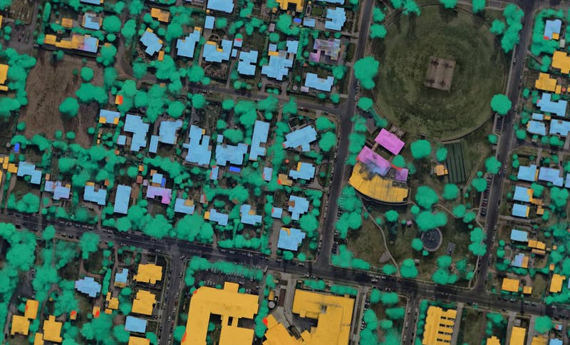
Aerial images for risk assessment underwriting
Carramar, WA, AU

Conduct Desktop Reviews with Nearmap

Remote property assessment is critical for insurers with millions of properties on their books. It reduces unnecessary site visits and costs, and can also streamline the customer experience.

With Nearmap, you won’t need to rely on a broker or homeowner for property insights. Instantly access current aerial imagery of a property to verify assets, identify features and measure structures. With Nearmap Oblique imagery, you’ll also be able to inspect facade and roof materials and condition from multiple angles.  Respond to customer inquiries quickly, and deliver quotes virtually, without compromising on critical detail. 

Oct 2020 | Kenthurst, NSW
Sep 2018 | Kenthurst, NSW

Check Veracity for Smoother Claims Processing

Make loss adjustment and the process of approving claims as smooth as possible with instant access to comprehensive recent and historic location imagery and data. 

Date-stamped capture data gives you the confidence to use Nearmap imagery for investigation if necessary, or go back through previous imagery of the location to see changes, renovations or recent improvements.  Compare before and after imagery of the property to check the scope of damage, cause and date, and then verify repair estimates from contractors.

aerial, roof, damage, Berowra Heights, NSW, 2018 December 28
Berowra Heights, NSW, AU

Respond Fast When They Need You Most

With its patented camera and processing technology, Nearmap captures imagery of areas immediately after most floods, hail, tropical storms and bushfires. In the last year alone, Nearmap has captured 28,000 km2 of post-bushfire imagery.

With rapid access to post-catastrophe imagery, you can review claims in a fraction of the time it would take on-site, enabling insurers to respond quickly to customers and speed up the claims process.

Customer Story

Have Quicker Policyholder Support with Nearmap

Kin's proactive approach to use aerial imagery to remotely assess properties allowed it to provide support for more than 50% of total claimants within the first 5 days of Hurricane Ian recovery in the US.

Read the Kin Story
See Hurricane Ian damage with aerial images
aerial, property, damage, Huntingwood, NSW, 2015 July 6
Huntingwood, NSW, AU

Join the mapping evolution

Up your aerial game and start working with high-res, current imagery of your work sites and properties. Get the advantage of premium geospatial content combined with world-class aerial mapping software and integrations.

Start the Conversation