Nearmap Announces Agreement to Acquire Betterview

Learn More
X
Nearmap Aerial Imagery in ArcGIS
Esri ArcGIS

Nearmap & ArcGIS: Boost Your Data-driven Insights

Strengthen your mapping and analytics capabilities using high-resolution aerial imagery.

Nearmap Imagery in ArcGIS
Nearmap Integration with Esri Gold Partner
Esri Family of Products

Sharper insights enable Smarter Decisions

Instantly and easily access high-resolution aerial imagery inside ArcGIS, Esri’s cutting-edge platform. As an industry leader in cloud-based content, Nearmap is proactively capturing high quality imagery across major urban areas in Australia, New Zealand, the United States and Canada. What does this mean for you? It’s imagery you can trust and rely on.

Bring Nearmap imagery into the suite of ArcGIS products: ArcGIS Online, ArcGIS Enterprise, ArcGIS Pro, ArcGIS Urban, ArcGIS Collector and ArcGIS Survey 123. Easily integrate Nearmap Vertical, Oblique and 3D content into ArcGIS to perform virtual site visits, gain greater awareness, and optimize location-based analyses.

Nearmap Aerial Imagery in ArcGIS Online

Complete Cloud-based Solution

Nearmap imagery is available online within days of capture. Using the ArcGIS Marketplace, stream up-to-date aerial data inside of ArcGIS Online applications; a complete, cloud-based solution for your project.

Nearmap Vertical and 3D content is release-ready—no coding required to start using aerial maps immediately. Increase your location intelligence inside a web-based environment with clear and contextually-sound aerial content. Offline imagery is available upon request.
Nearmap Oblique for ArcGIS

Comprehensive Imagery for Your Applications

Create powerful 2D and 3D web applications through ArcGIS Web AppBuilder. Elevate your ArcGIS Online and ArcGIS Enterprise content with Nearmap’s current and historical imagery. With industry-leading resolution of 5.5cm-7.5cm GSD, create maps, solve problems, and share geospatial data with enhanced detail.

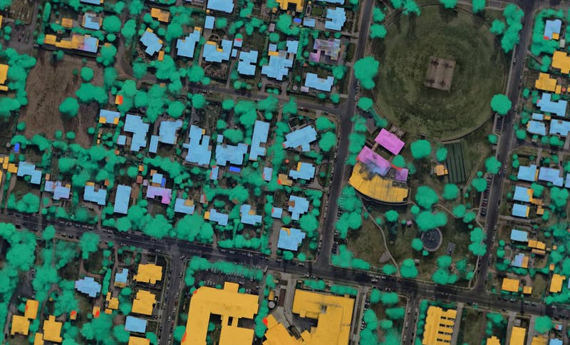
Add measurable oblique imagery from Nearmap into your ArcGIS Enterprise experience and derive greater analytical insights for your base map layers. Get a more natural, on-the-ground view of the real world, all at a 45-degree angle.

Nearmap 3D in Esri ArcGIS Urban
Nearmap 3D in ArcGIS Urban

Greater Context for Your Data

Overlay your ArcGIS data onto stunningly clear Nearmap imagery for a rich, contextually accurate viewing experience. Leverage 2D and 3D content from Nearmap to provide the most current, real-world basemap for your data inside ArcGIS Pro. Generate immersive, realistic 3D modeling for your project planning within ArcGIS Urban.

Nearmap Aerial Imagery On the Go

Intensify Field Operations

Take Nearmap on-the-go and improve efficiency for your site visits and field activities by gaining better in-field perspectives with accurate, contextual location content. Nearmap imagery seamlessly fits into your ArcGIS Collector and ArcGIS Survey 123 mobile workflows.

Simple & Powerful Integrations

ArcGIS System Ready logoWith no coding required, easily integrate Nearmap imagery into ArcGIS via a few different methods: ArcGIS Marketplace, WMS (Web mapping service), MapBrowser Export, or the Web AppBuilder widget. Please visit our Help Centre for more information.

Integration Method

ArcGIS Marketplace

WMS (Web Mapping Service)

MapBrowser Export

Web AppBuilder Widget

Nearmap Product

Vertical

Vertical

Vertical / 3D

Oblique

Features

  • Current and historical imagery
  • Change coordinate system/projections
  • Share within your groups
  • Current & historical imagery
  • Perform geofencing
  • Change coordinate systems/projections
  • API Key authentication
  • 3D Content: Textured mesh/DSM/Point Cloud/True Ortho
  • Georeferenced Imagery
  • High-Resolution Imagery
  • Screenshots
  • “Oblique Viewer for Nearmap” Widget
  • Integrate into ArcGIS Enterprise apps
  • Measurable
  • Four Directional Perspectives

ArcGIS Platform

ArcGIS Online

ArcGIS Enterprise

ArcGIS Collector

ArcGIS Survey 123

ArcMap

ArcGIS Online

ArcGIS Pro

ArcGIS Enterprise

ArcGIS Enterprise

ArcGIS Online

ArcGIS Pro

ArcGIS Urban

ArcGIS Enterprise

ArcGIS Web AppBuilder

Burwood East Construction Site Aerial Image
Dec 2019 | Burwood East, VIC

Join the mapping evolution

Up your aerial game and start working with high-res, current imagery of your work sites and properties. Get the advantage of premium geospatial content combined with world-class mapping software and integrations.

Start the Conversation